John Snook, Westtown Township's land planner, testified Tuesday night that the Toll Bros. proposed development of Crebilly Farm can happen if some of the homes are shifted farther to the east. That was the same thing he said in September of 2017 during the first round of conditional use hearings for the project.
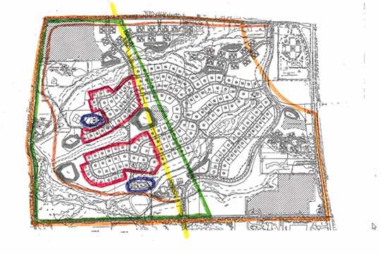
Toll wants to build a 319-home development on the 320-plus-acre farm site bordered by Routes 202 and 926 on the east and south, and S. New Street and West Pleasant Grove Road on the west and north.
Snook is a former senior land planner with the Brandywine Conservancy. Under direct examination from Kristin Camp, the solicitor for Westtown's Planning Commission, Snook said the Crebilly tract had been deemed eligible for inclusion into the National Register of Historic Places by the Pennsylvania Historical and Museum Commission.
The western portion of the property was where there was Hessian troop movement during the 1777 Battle of Brandywine and that there could have been shots fired from that location toward Sandy Hollow in Birmingham, Snook said.
"The amount of the tract within the designation is obviously large so, my view is, as suggested by the [Chester] county Planning Commission, that the plans be revised to pull the development out of the particular likely troop movement and maintain the ability to interpret those movements upon the landscape by moving more of the development toward the east," he said.
Snook added the plan should also show adaptive re-use of all the historic buildings on the site, not just some, as Toll has already agreed to do.
Under further questioning, Snook said the township's comprehensive plan designates the far western area of the Crebilly tract for use as open space and a greenway. Greenways are those areas with a concentration of flood plains, wetlands, and steep slopes.
"They are largely considered appropriate — and recommended frankly — for a conservation focus. They're also noted in the comp plan that, because they're linear in nature, they may also be the logical setting for trail interconnections," he said.
Snook went further, saying the comprehensive plan notes open space as "historically significant agriculture lands." It also calls for the negotiation with property owners and developers for permanent conservation of those areas deemed key, "including lands designated as open space through the subdivision process."
Camp asked for his recommendation on how Toll's conditional use plan should be changed to meet the township's comprehensive plan's goals.
"The development plans, as submitted, are generally consistent with the designation of the greenway. They basically leave that main stem, that Radley Run corridor, alone…Almost half of the proposed development is in area denoted by the comprehensive plan's future land use map as open space. As mentioned before, and as Chester County has recommended, I support moving more of the development in the west to the east to help preserve that open space area," Snook said.
Snook also spoke of the recommendations in Landscapes3, the county's comprehensive plan, but added under cross-examination from attorney Gregg Adelman, representing Toll, that there are no requirements in Westtown's Zoning Code requiring compliance with Landscapes3.
However, he said, "There are recommendations in the comp plan itself, and the township's zoning ordinance asks for consistency with the comp plan, but there's no specific link, other than being a valuable recommendation source.
The questioning moved back to Westtown's future land use map when Adelman asked whether the map shows various uses for the farm other than those listed on the township zoning map.
"Absolutely," Snook said.
He then explained that the future land use map is an "idealized" future character. "It is not a zoning map."
Also, under questioning from Adelman regarding trails, Snook acknowledged that the zoning ordinance does not require the applicant to construct a perimeter trail.
"The zoning ordinance provides for provisions for trails, but it does not designate specific locations, other than the more general requirement to be consistent with the comp plan," he said. "The comp plan has done this."
Adelman's questioning then led back to the Battle of Brandywine and to what degree the Crebilly site played a part in that battle. Under questioning, Snook said the farm is not part of the Brandywine Battlefield National Historic Landmark but said that was a matter of timing.
"It's not part of the original landmark area that was designated in the 1960s, and it's important to note that the original designation didn't even have a map area," he said. "A few years later they threw a map up but, for years, the National Park Service, through the American Battlefield Protection Program and the Chester County Planning Commission have used a larger study area especially when more information came out with diaries that were discovered about the [troop] movement."
That movement came up from Kennett Square, almost to the Marshallton area, and then back down along Birmingham Road and New Street. Snook said those areas were not included in the original landmark designation because people didn't know much about them at the time.
"History is an ongoing, information gathering process," Snook said.
The conditional use hearing is also an ongoing process, and the next two sessions are already scheduled. The first is set for Feb. 23, and the other for March 23. Both will be conducted via Zoom at 7 p.m.
About Rich Schwartzman
Rich Schwartzman has been reporting on events in the greater Chadds Ford area since September 2001 when he became the founding editor of The Chadds Ford Post. In April 2009 he became managing editor of ChaddsFordLive. He is also an award-winning photographer.


 (11 votes, average: 3.64 out of 5)
Comments