There are a number of legalities involved when a person buys or sells real estate. Those legalities can become complicated and they can become even more so when a recorder of deeds office can’t or won’t provide proof about who owns what.
That’s the situation for Carol Wolf and her son Ken Wolf. Four acres of Carol Wolf’s property seem to have been transferred to a railroad without her knowledge or consent.
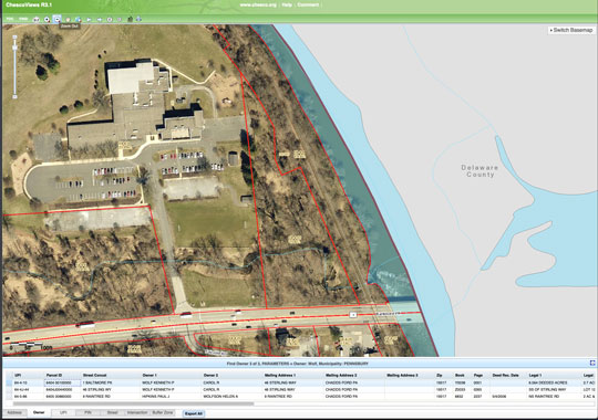
ChescoViews, Chester County’s online database of properties, shows a map with Carol Wolf owning 2.7 acres. Yet, a notation on the bottom of the page says she owns 6.564 acres. That discrepancy has been a problem. Her son said many people can’t see that bottom portion and at least 10 potential buyers have walked away from a purchase because they think his mother is being deceptive.
The background
In 1966, Carol Wolf, now 85, and her late husband, Kenneth Wolf Sr., bought a woodland property in Pennsbury Township from Paul and Emilie Reyburn. The property — with the address of 1 Baltimore Pike — is situated between Chadds Ford Elementary School and the Brandywine Creek. The deed, the title search and a land survey from 1966 show the family buying the 6.564-acre piece of property.
A railroad line runs through part of the property and East Penn Railroad holds an easement on that stretch, something which no one denies. But somewhere along the line — sometime during the 1930s, Chester County contends — the additional 4 acres were deeded to the railroad. But the county hasn’t provided the Wolfs with any proof, no actual deed.
In 1982, PennDOT condemned the railroad easement and, using a quitclaim deed, bought the easement so that stretch could be used for the Rails-to-Trail project. PennDOT paid $900,000 for the easement but sold it back to ISG Railways for $500,000 in 2001 after deciding not to move forward with Rails-to-Trails.
In 2006, Ken Wolf said, his mother decided to sell the land, thinking it was all 6.564 acres. That’s when they learned there was a problem. 
In 2005, ISG sold the easement to East Penn Rail Road for $75,000 but, somehow, apparently, included 4 acres from outside of the easement area. However, Chester County has not provided the Wolfs with any proof of when or how the railroad legally claimed those extra 4 acres, if ever.
Further convoluting matters is that Ruth Huganir, Chester County’s first deputy recorder of deeds, told the family that the railroad has owned the property since the 1930s, but hasn’t provided any documentation proving that contention.
During a telephone interview, Huganir neither confirmed nor denied telling the Wolfs that the railroad has owned the property since the 1930s. She can’t verify whether there is or is not a deed showing East Penn Railroad owning the 4 acres in question without having a citation to reference, she said.
When asked how she could have told the Wolfs that the railroad has owned the four acres the last 80 years without offering proof, she repeated that she can’t answer that “without a citation.” But Huganir sent Wolf an email on March 22 of this year saying:
“UPI # 64-4-4 has been owned by the railroad since the 1930s.
“Your mother’s parcel, 64-4-10, was not cited, nor referenced, in the quitclaim deed from one railroad to the other.
“UPI 64-4-4 was cited and its ownership was verified by the BLR. As the owner in title, the railroad was entitled to transfer that parcel to another entity – in this case – another railroad…”
[UPI is one of the designators of a specific parcel of land.]
No deed was provided, nor does the email indicate when the railroad bought the 4 acres in the first place. Nor did Huganir indicate when or how the Bureau of Land Records verified ownership. BLR is part of the Recorder of Deeds office.
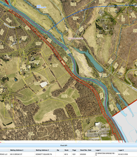
UPI# 64-4-4 shows East Penn Railroad owning 8.8 acres, of which 4 acres, Wolf thinks, came from his mother’s property and was possibly double deeded.
In a follow-up interview, Huganir acknowledged the Wolf property is 6.564 acres and that the Wolfs were only assessed on the 2.7 acres because wetlands and slopes make the remaining 4 acres unbuildable. But she then said those extra acres are part of the railroad easement. Yet, she doesn’t know when or how that came about, nor will she look for any evidence.
“I’m a librarian, not a researcher. If the documents exist in my records, then a researcher, licensed and bonded, should be able to find it.”
When asked whose responsibility it is to provide that researcher to find proof that the acreage in question is owned by the railroad, Huganir said was up to Ken Wolf. And when asked, again, whether county records show when the railroad bought the land, she responded by saying “I can’t answer you. I don’t know.”
While Huganir contends the easement includes 4 acres of the Wolf property, at least one representative from PennDOT believes that’s wrong.
PennDOT’s Right of Way Administrator Roger Joseph said the easement is much smaller, less than 1 acre. The easement is 60 feet to both sides of the center of the rail line, though the actual width varies in places, he said.
“The previous owners [the Reyburns] owned 7.479 acres. If you subtract Wolf’s 6.564 acres you get 0.915 acres,” and that is closer to the actual easement area.
The question that lingers is how and when did the railroad acquire those extra acres — either through outright purchase or through an easement — or if there was a clerical error somewhere.
Ken Wolf also said his mother contacted the county tax office in 2006 to affirm property rights and was told she did indeed own 6.56. The family also has a letter from the former Chief Tax Assessor Robert McRae dated May 2006 verifying that Carol Wolf owns all the acreage.
In an email dated Aug. 17, 2017, John Schuck, the current director of tax assessment, told the Wolfs that there was no railroad deed found before 1966.
“A review of county records could not locate a deed prior to 4/18/1966 for the portion of [the railroad] that passes through the Wolf property,” Schuck wrote.
That email also said, “The county does not make any claim regarding legal rights/obligations the railroad may or may not have relative to the Wolf property, as there is no recorded documentation to evaluate such a claim.”
Wolf said Rick Loughery, the current recorder of deeds, told him that the county would do nothing more than making the addendum on the bottom of the ChescoViews page.
Ken Wolf said having the notation on the bottom of that page isn’t good enough. Many people don’t see that he said, and sometimes it doesn’t show up. But prospective buyers see the map and think his mother is trying to sell something she doesn’t own.
Wolf said he and his mother would be OK with just being able to sell only 2.7 acres but want proof of that being factual. They would both prefer the map on ChescoViews to be corrected to show Carol owning all 6.564 acres.
Until there is some resolution regarding how much land can be sold, an 85-year-old widow is losing opportunities.
About Rich Schwartzman
Rich Schwartzman has been reporting on events in the greater Chadds Ford area since September 2001 when he became the founding editor of The Chadds Ford Post. In April 2009 he became managing editor of ChaddsFordLive. He is also an award-winning photographer.
 (7 votes, average: 5.00 out of 5)

Comments